GNSS Reciever Point 3

  • 1408 GNSS channels – control of all current and future signals
  • Fix support – in areas with poor Internet coverage
  • Efficient power supply  – up to 10 hours of operation
  • Easy to use – intuitive software in Polish

   Ask for product   

Category:
Description

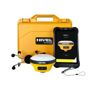
A new generation of GNSS receivers with IMU for speed and convenience – it’s time to buy yours

In need of a versatile GNSS receiver?

Need to measure or find some outdoor landmarks?

Not sure what an IMU is and whether you might find it useful?

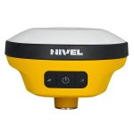
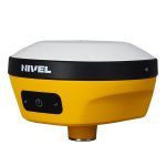
Well, you’ve come to the right place! We are here to answer all your questions and explain how to use a state-of-the-art GNSS receiver – the Nivel System Point 3, equipped with a proven latest-generation IMU – in the field.

What is IMU? And why will you make your job easier?

The latest generation IMU is an ultra-modern 9-axis inertial system that enables a rod pitch of +/- 90 degrees. And what’s it all for?

It allows you to measure points that are beyond the capabilities of normal receivers. These include locations where the horizon/sky is obscured (e.g., under trees or on buildings). This system is also perfect for daily measurements – you can measure any point faster without having to accurately calibrate the rod.

The spirit level does not need to be constantly monitored when taking measurements at building corners and recording other data.

The features also work well for measuring and marking the following:

  • points, e.g., under a parked car or other obstacle; hard-to-reach areas covered with lush vegetation, e.g., building facades, fences; difficult-to-reach small watercourses and ditches; loose dumps, fall areas – by increasing safety and avoiding dangerous edges; on busy roads – a quick measurement from a safe distance avoids the risk of walking on a busy stretch of road.

Our IMU is resistant to magnetic interference. Thus, metal elements (e.g., fences, roofing, reinforcements) cannot interfere with the inclinometer measurement.


Point3 Nivel System

What you gain by working with Nivel System Point 3

ikony kanaly

1408 GNSS channels

Processing of current and future satellite signals from the 4 GNSS systems

ikony net

Fix support

in areas with poor Internet coverage

ikony strona1

Live view

See all results instantly at the time of measurement

ikony antena

Standardowo wyposażony jest w radiomodem UHF o możliwości pracy nawet do 8 km. Współpracuje z innymi markami odbiorników i w trybie baza/rover.

ikony bateria

Efficient power supply 

up to 10 hours of operation

ikony pamiec

8 GB internal memory

Option to record several days of static observations

ikony dokl

Centimetre accuracy

Thanks to the unique automatic monitoring feature, the reproducibility of the measured position is guaranteed at all times

ikony kabl

Freedom thanks to wireless technology

Bluetooth, WiFi and NFC communication modules for convenient pairing and data synchronisation

ikony PL

Fully compatible with NSurv

The software is compatible with CAD data

ikony tablet

Android tablet

Instant synchronisation of measured data in the cloud or by email enabled by the option to connect to your own mailbox

Equipment

Included:

– Nivel System Point 3 receiver, NT-1024 tablet, pole holder
– Nsurv surveying software
– USB multi-port charger, USB-C cable
– replaceable battery for the tablet
– choice of several pole models
– small, lightweight carrying case
– digital user manual in Polish
– receiver certificate

Specification

GNSS RECEIVER POINT 3

Tracked Signals (all unlocked):

GPS: L1 / L2 / L5 / L2C

GLONASS: L1 / L2 / L3

Galileo: E1 / E5 AltBOC / E5a / E5b / E6

Beidou: B1 / B2 / B3 / B1C / B2a

QZSS: L1 / L2 / L5 / L6

IRNSS: L5

SBAS: L1 / L5

L-Band: Receiving corrections from the global reference station network via geostationary satellite (without GSM coverage)

Number of Channels: 1408

Positioning Accuracy in RTN Mode:

Horizontal: 8mm+0.5ppm RMS

Vertical: 15mm+0.5ppm RMS

Positioning Accuracy in RTK Mode:

Horizontal: 8 mm+1 ppm RMS

Vertical: 15 mm+1 ppm RMS

Internal Memory: 8GB

Operating Temperature: – 30 to +70 °C

IP Standard: IP67, free fall from 2m height

Weight: 0.8 kg (with battery)

Size: 132mm×67mm

Operating Time / Charging: up to 12-15 h

UHF Radiomodem: 0.5W-2W (adjustable), range up to 8km, supports protocols: HI-TARGET, TRIMTALK450S, TRIMMARK III, TRANSEOT, SATEL-3AS, etc.

TABLET NT-1024

Operating System and Processor: Android 13.0, 2.0GHz, 8-core high-speed processor

Memory: RAM 6GB, ROM 128GB, additional SD card 256 GB

Display: 8-inch display, touchscreen

Resolution: 1280×800, sunlight readable

Rear Camera: 16M pixels, front camera 8M pixels, autofocus, LED flash

Operating Time / Charging: up to 8 hours, charging ≤ 5 hours

Size: 235mm×146mm×14.5mm

Weight: 610g (with battery)

Operating Temperature: -20℃ ~ +60℃ Storage Temperature: -40℃ ~ +70℃

IP Standard: IP67, free fall from 1.2m height